Package org.geotools.api.style
The following package is an implementation of OGC Symbology Encoding 1.1.0 and ISO 19117 : Portrayal
This package is a merge from package GeoAPI SLD (v1.0.0) and GeoTools styling.Symbology Encoding overview
Source : http://www.opengeospatial.org/standards/symbolFile : 05-077r4
This document defines an XML encoding that can be used for styling feature and
coverage data.
Symbology Encoding includes the FeatureTypeStyle as root element.
These elements include all information for styling the data such as Filter and different
kinds of Symbolizers.
As Symbology Encoding is a grammar for styling map data independent of any service
interface specification it can be used flexibly by a number of services that style
georeferenced information or store styling information that can be used by other services.
Symbology Encoding is a specification that define styles in xml files. This GeoAPI implementation may be a bit different from the original XSD structure to offer a better integration in the Java langage and to follow ISO 19117.
Here are schemas breafly describing the java implementation :
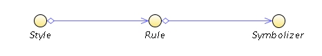
- Styles have N rules, and each rule have N Symbolizers.
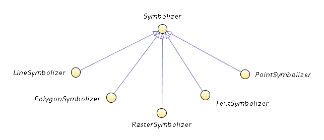
- We found Symbolizer for each data type we can portray.
-
ClassDescriptionAn AnchorPoint identifies the location inside a textlabel to use as an "anchor" for positioning it relative to a point geometry.The ChannelSelection element specifies the false-color channel selection for a multi-spectral raster source (such as a multi-band satellite-imagery source).The ColorMap element defines the mapping of palette-type raster colors or fixed- numeric pixel values to colors using an Interpolate or Categorize SE functionA basic interface for objects which can hold color map entries.The ColorReplacement element, which may occur multiple times, allows to replace a color in the ExternalGraphic, the color specified in the OriginalColor sub-element, by another color as a result of a recode function as defined in Interpolate.The ContrastEnhancement object defines contrast enhancement for a channel of a false-color image or for a color image.The ContrastEnhancement element defines contrast enhancement for a channel of a false-color image or for a color image.This interface defines the strategy that a ContrastEnhancement will use to execute the ContrastMethod that it has defined.A Description is used to store various informations who describe an element.The Displacement gives the X and Y displacements from the original geometry.An symbolizer interface for all unnormalized symbolizers, This interface should be used for vendor specific symbolizers.An Extent gives feature/coverage/raster/matrix dimension extent.Points to an external file that contains an image of some kind, such as a CGM, JPG, or SVG.The alternative to a WellKnownName is an external mark format.A FeatureTypeConstraint identifies a specific feature type and supplies filtering.Represents a style that applies to features or coverage.Indicates how the interior of polygons will be filled.The Font element identifies a font of a certain family, style, and size.Enumeration of allow font-style values.Enumeration of allow font-weight values.A Graphic is a "graphic symbol" with an inherent shape, color(s), and possibly size.Common superclass for the two types of markers that can appear as children of a
Graphicobject, namelyMarkandExternalGraphic.A GraphicFill is a simple interface with only a graphic but additional parameters for the GraphicFill may be provided in the future to provide more control the exact style of filling.The LegendGraphic element allow an optional explicit graphic symbolizer to do displayed in a legend for the rule.The GraphicStroke element both indicates that a repeated-linear-graphic stroke type will be used.A Halo is a type of Fill that is applied to the backgrounds of font glyphs.ImageOutline specifies how individual source rasters in a multi-raster set (such as a set of satellite-image scenes) should be outlined to make the individual-image locations visible.The LabelPlacement element is used to position a label relative to a point, line string or polygon.LayerFeatureConstraints define what features and feature types are referenced in a layer.The "LinePlacement" specifies where and how a text label should be rendered relative to a line.Gives directions for how to draw lines on a map.Indicate that one of a few predefined shapes will be drawn at the points of the geometry.A NamedLayer is used to refer to a layer that has a name in a WMS.A NamedStyle is used to refer to a style that has a name in a WMS.Allows open ended extensions for text oriented rendering formats.The OverlapBehavior element tells a system how to behave when multiple raster images in a layer overlap each other, for example with satellite-image scenes.A PointPlacement specifies how a text label is positioned relative to a geometric point.Indicates how to draw point geometries on a map.Holds the information that indicates how to draw the lines and the interior of polygons.The RasterSymbolizer describes how to render raster/matrix-coverage data (e.g., satellite photos, DEMs).A RemoteOWS gives a reference to a remote WFS/WCS/other-OWS server.Provides a hook to locate online resources inExternalGraphicinstances.A class to hold Channel information for use in ChannelSelection objects.Identifies the more general "type" of geometry that this style is meant to act upon.The ShadedRelief element selects the application of relief shading (or “hill shading”) to an image for a three-dimensional visual effect.Contains all the information needed to draw styled lines.A UserStyle is at the same semantic level as a NamedStyle used in the context of a WMS.'StyledLayer' is not part of the SLD 1.0 spec.Holds styling information (from a StyleLayerDescriptor document).Factory used in the production of style objects.An interface for classes that want to perform operations on a Style hierarchy.This a mostly empty interface for styling symbol objects to implementAbstract superclass of the symbolizers defined by the Symbology Encoding specification.Indicates how text will be drawn.DisplacementMode associates an angle with each enum valueGraphicPlacemnts controls the position of the Graphic associated with the labelEnumerated options that can be used with polygonAlign.An interface for classes that want to perform operations on a Style hierarchy.A UserLayer allows a user-defined layer to be built from WFS and WCS data.