Bounds
Bounds are used to represent the extent of a geometry, and are used very frequently as a way to quickly check if a geometry is in the area you are interested in.
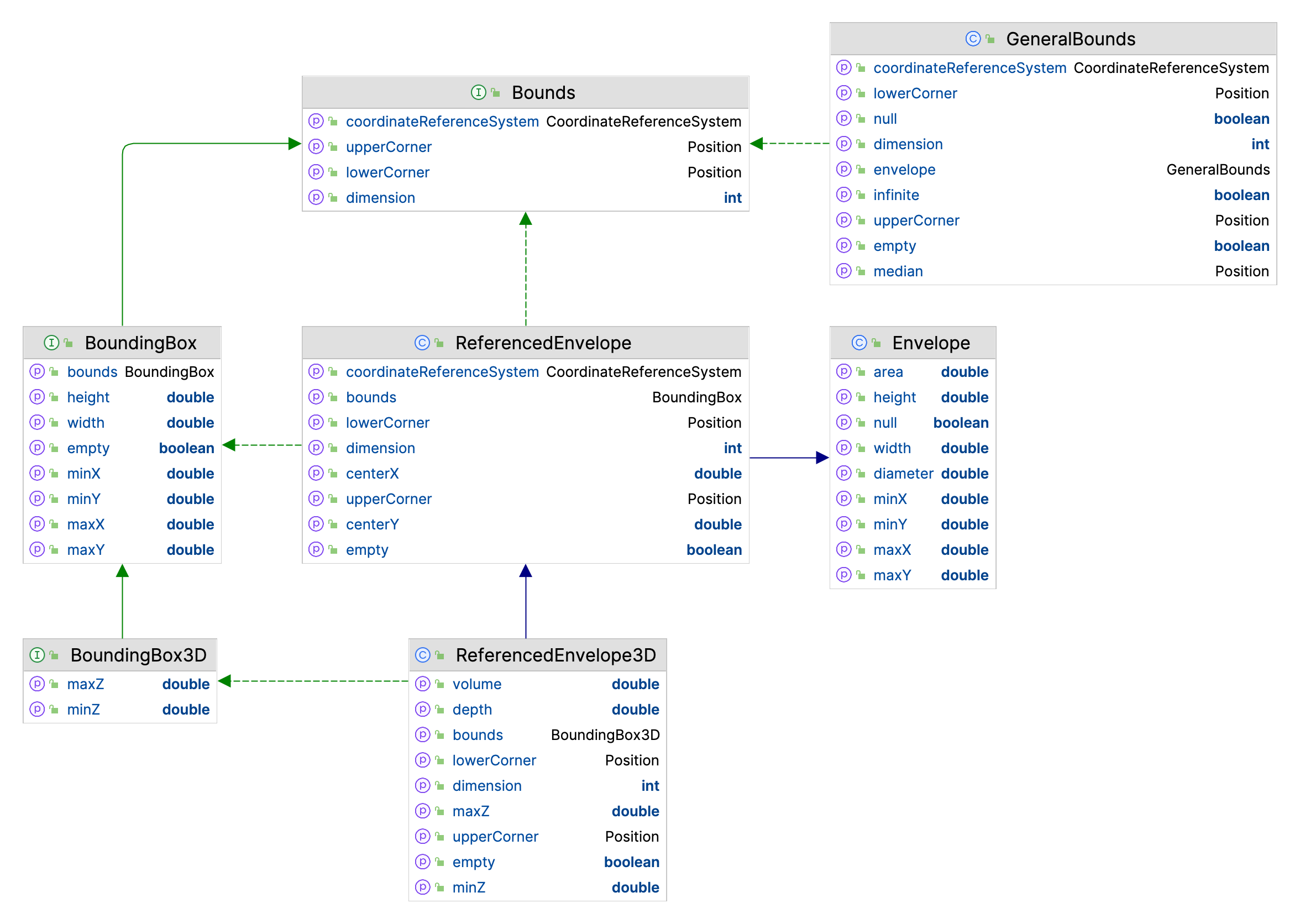
GeoTools, through virtue of reusing code, has seveal “Bounds” implementations to contend with:
gt-apimoduleBoundsandBounds3Drepresenting a spatial extent, complete withCoordinateReferenceSystem.The Coverage API in
gt-apipackageorg.geotools.api.coveragemakes use ofBoundsandBounds3Dextensively.gt-apimoduleBoundingBoxandBoundingBox3Drepresent a spatial extent, assumingCoordinateReferenceSystemdefines axis inX/Yorder.gt-referencingimplementsAbstractBoundsandGeneralBounds, to the area of validity for a coordinate reference system.gt-maindefinesReferencedEnvelopewhich is adds aCoordinateReferenceSystemto a JTS Topology SuiteEnvelope. The classReferencedEnvelope3Dsupports a third dimension on top of the regular two dimensions.DataStore API
gt-mainpackagesorg.geotools.api.datamakes use ofReferencedEnvelopeandReferencedEnvelope3Dextensively (integrating well with use of JTSGeometry).
You will find other “Rectangles” around as you make use of GeoTools in a real world application.
Java
RectanglesJava
Rectanglesrecord x,y,w,h:Rectangle2DRectangle2D.Doublerectangle working with doublesRectangle2D.Floatrectangle working with floats
GeneralBoundswe have a spatial specific version ofRectangle2Dthat implements ISO Geometry EnvelopeRectanglethe originaljava.awtrectangle for working on the screen, measured in integer pixels.
ReferencedEnvelope and ReferencedEnvelope3D
GeoTools ReferencedEnvelope extends JTS Envelope to implement the gt-api module Bounds interface,
and subclass ReferencedEnvelope3D implementing Bounds3D.
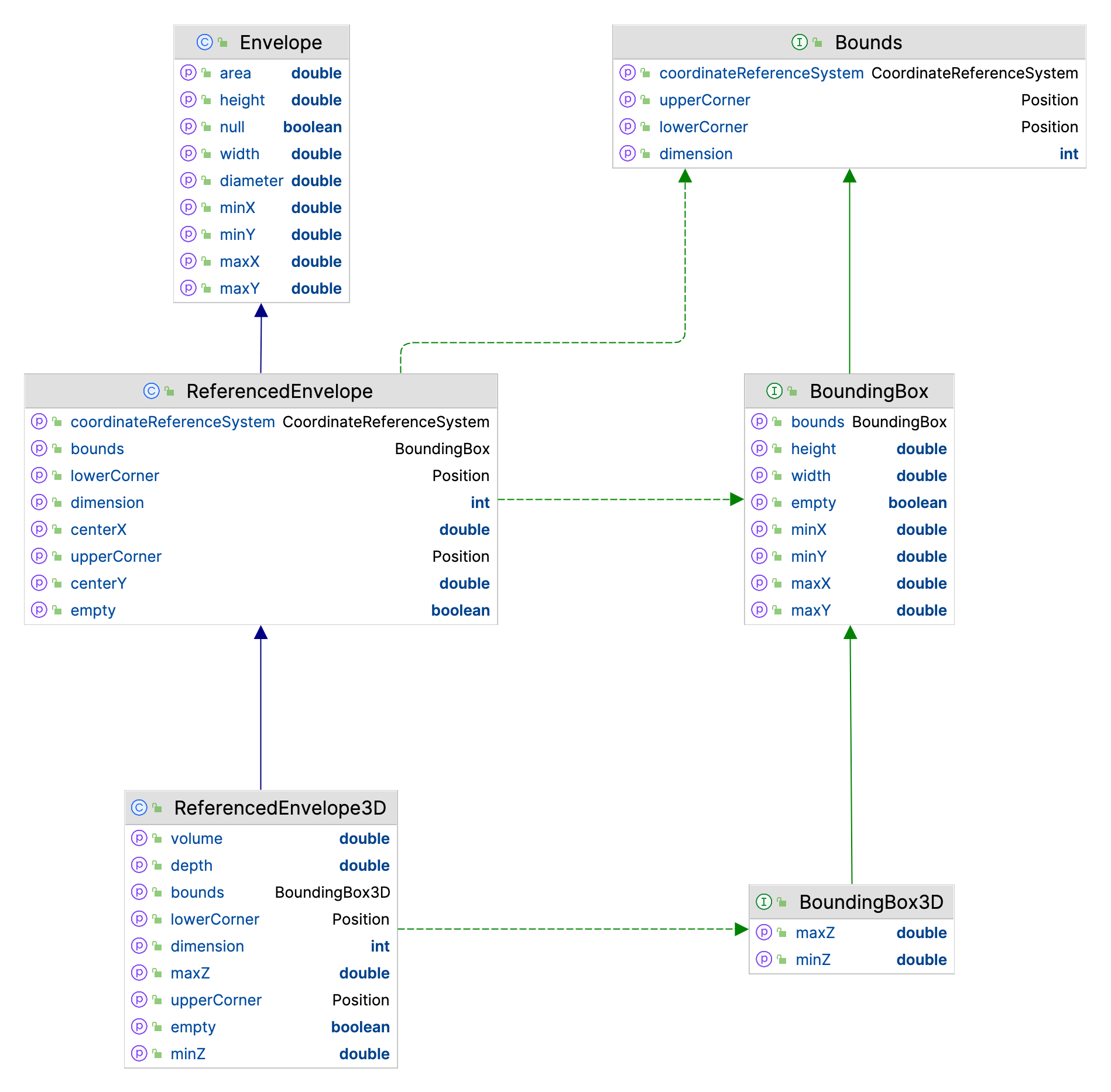
Use of ReferencedEnvelope is the most common representation of a bounds in GeoTools:
ReferencedEnvelope envelope = new ReferencedEnvelope(0, 10, 0, 20, DefaultGeographicCRS.WGS84);

double xMin = envelope.getMinX();
double yMin = envelope.getMinY();

double xMax = envelope.getMaxX();
double yMax = envelope.getMaxY();

double width = envelope.getWidth();
double height = envelope.getHeight();

double xCenter = envelope.getMedian(0);
double yCenter = envelope.getMedian(1);

CoordinateReferenceSystem crs = envelope.getCoordinateReferenceSystem();
int dimension = envelope.getDimension();

// Direct access to internal upper and lower positions
Position lower = envelope.getLowerCorner();
Position upper = envelope.getUpperCorner();

// expand to include 15, 30
envelope.include(15, 30);

envelope.isEmpty(); // check if storing width and height are 0

envelope.isNull(); // check if "null" (not storing anything)
envelope.setToNull();
Bounds and GeneralBounds
The gt-api module records Bounds as an extent measured along each axis mentioned by the CoordinateReferenceSystem object. You can use this approach to record a simple rectangle in space, a height range, and a range in time as needed.
The GeneralBounds implementation records spans in multiple dimensions (think depth, height or time).
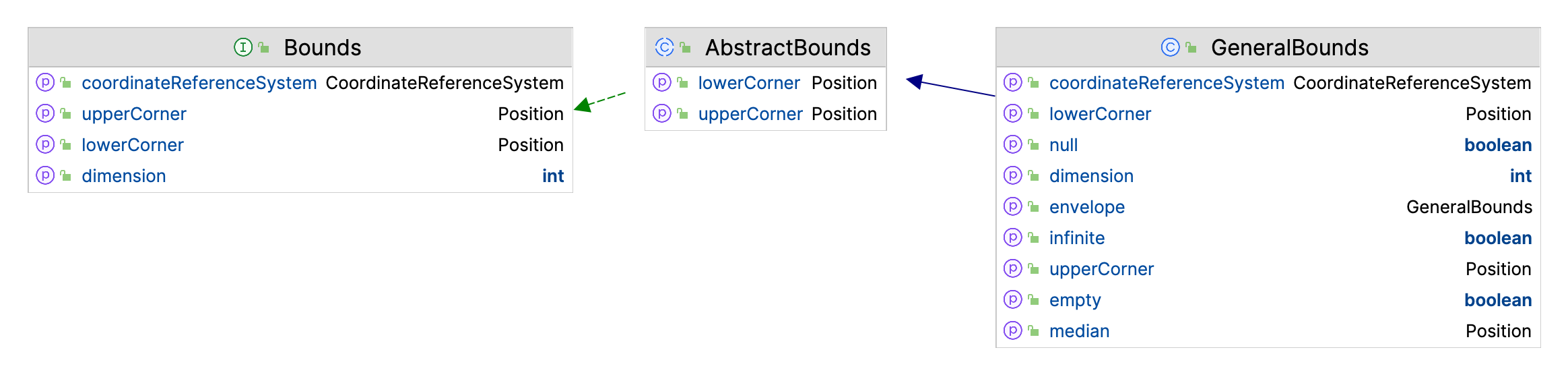
Since``Bounds`` is an interface we will work with GeneralBounds in this example:
CoordinateReferenceSystem wsg84 = CRS.decode("EPSG:4326");

GeneralPosition lowerPosition = new GeneralPosition(0.0, 0.0);
lowerPosition.setCoordinateReferenceSystem(wsg84);

GeneralPosition upperPosition = new GeneralPosition(10.0, 20.0);
upperPosition.setCoordinateReferenceSystem(wsg84);

Bounds bounds = new GeneralBounds(lowerPosition, upperPosition);

double xMin = bounds.getMinimum(0);
double yMin = bounds.getMinimum(1);

double xMax = bounds.getMaximum(0);
double yMax = bounds.getMaximum(1);

double width = bounds.getSpan(0);
double height = bounds.getSpan(1);

double xCenter = bounds.getMedian(0);
double yCenter = bounds.getMedian(1);

CoordinateReferenceSystem crs = bounds.getCoordinateReferenceSystem();

// Direct access to internal upper and lower positions
Position lower = bounds.getLowerCorner();
Position upper = bounds.getUpperCorner();

// expand to include 15, 30
lower.setOrdinate(0, Math.min(lower.getOrdinate(0), 15));
lower.setOrdinate(1, Math.min(lower.getOrdinate(1), 30));
upper.setOrdinate(0, Math.max(upper.getOrdinate(0), 15));
upper.setOrdinate(1, Math.max(upper.getOrdinate(1), 30));
Even in a simple example we should consult the CRS to define what each axis is measuring (the variables showing xMin and yMin hold unexpected values if the CoordinateReferencSystem defines Axis 0 as NORTHING)
BoundingBox and BoundingBox3D
If you are confident that you are working with data in X/Y order you can directly make use of BoundingBox box. BoundingBox is an extension of Envelope for working with 2D data, and it has been made method compatible with JTS Envelope where possible.
Since BoundingBox is just an interface, so we will use ReferencedEnvelope for this example:
CoordinateReferenceSystem wsg84 = CRS.decode("EPSG:4326");
org.geotools.api.geometry.BoundingBox bbox = new ReferencedEnvelope(0, 10, 0, 20, wsg84);

double xMin = bbox.getMinX();
double yMin = bbox.getMinY();

double xMax = bbox.getMaxX();
double yMax = bbox.getMaxY();

double width = bbox.getWidth();
double height = bbox.getHeight();

double xCenter = bbox.getMedian(0);
double yCenter = bbox.getMedian(1);

CoordinateReferenceSystem crs = bbox.getCoordinateReferenceSystem();

// Direct access to internal upper and lower positions
Position lower = bbox.getLowerCorner();
Position upper = bbox.getUpperCorner();

// expand to include 15, 30
bbox.include(15, 30);
JTS Envelope
The JTS Topology Suite has the concept of an Envelope recorded in x1,x2, y1,y2 order.
You can see that the use of JTS Envelope has the same “assumptions” as the use of BoundingBox above.:
org.locationtech.jts.geom.Envelope envelope = new Envelope(0, 10, 0, 20);
double xMin = envelope.getMinX();
double yMin = envelope.getMinY();

double xMax = envelope.getMaxX();
double yMax = envelope.getMaxY();

double width = envelope.getWidth(); // assuming axis 0 is easting
double height = envelope.getHeight(); // assuming axis 1 is nothing

// Expand an existing envelope
Envelope bbox = new Envelope();
envelope.expandToInclude(bbox);

// Use
envelope.covers(5, 10); // inside or on edge!
envelope.contains(5, 10); // inside only

// Null
envelope.isNull(); // check if "null" (not storing anything)
envelope.setToNull();
Transform an Envelope using the JTS Utility class:
CoordinateReferenceSystem sourceCRS = CRS.decode("EPSG:4326");
CoordinateReferenceSystem targetCRS = CRS.decode("EPSG:23032");

Envelope envelope = new Envelope(0, 10, 0, 20);

MathTransform transform = CRS.findMathTransform(sourceCRS, targetCRS);

Envelope quick = JTS.transform(envelope, transform);

// Sample 10 points around the envelope
Envelope better = JTS.transform(envelope, null, transform, 10);