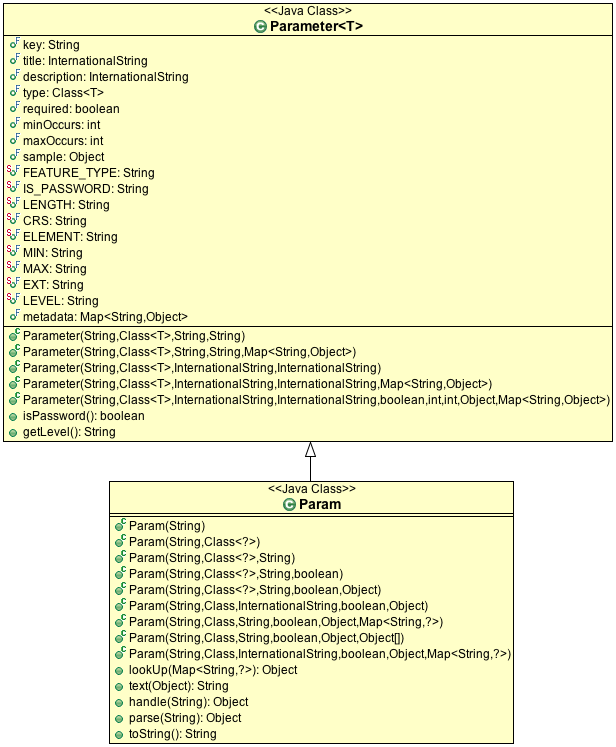
Parameter
The connection parameters are described using the Parameter class. There is also a small
extension to this idea with the DataAccessFactory.Param class. The extension provided
for backwards compatibility, as the methods focus on data entry and has been
superseded by the Converters class.
The Parameter is used for:
DataAccessFactory.getParameterInfo()To describe the keys and values to put into your map. You can use this information to ask your end users the details about their data such as if they want an index created for their shapefile access.
ProcessFactoryingt-processto describe the parameters to geospatial processes.JDataStoreWizardfromgt-swingused to allow users to connect to data in our tutorials.
In all these cases the Parameter are used to describe the contents of a Map<String,Object>.
The class itself is open ended, with only a few well defined restrictions advertised at this time.
The following public fields are available:
Parameter.key:StringProgrammatic machine readable key or name used to store the value. Suitable for use in a
java.util.Mapof connection parameters.Parameter.type:Class<T>Formal restriction on the type of the Java Object allowed as a value. May be used in conjunction with
minOccursandmaxOccurswhen aListof values is allowed.Parameter.title:InternationalStringParameter.description:InternationalStringHuman readable title and description for data entry prompting.
Parameter.required:booleanParameter.minOccurs:intParameter.maxOccurs:intIndication of if the value is required, or if more than one value is allowed and any restrictions on the resulting list.
Parameter.sample:ObjectA sample, or default, value that can be shown to users as a starting point.
Parameter.metadata:Map<String, Object>Here is where the
Parameterdescription becomes open ended, as you can add your own restrictions and information to this “metadata” map.We have defined a series of well known keys (with javadocs):
FEATURE_TYPE- when theParameter.typeis aSimpleFeature, this key is used to record the expectedFeatureTypeIS_PASSWORDExample use:
// Using IS_PASSWORD to check Parameter.metadata
field.setPassword( Boolean.TRUE.equals( parameter.metadata.get( Parameter.IS_PASSWORD )));

// Or use the utility method
field.setPassword( parameter.isPassword() );
LENGTHExample use:
Integer length = parameter.metadata.get( Parameter.LENGTH );
field.setLength( length == null ? 40 : length );
CRS- when the parameter type is spatial (such as aGeometryorFeature) this records the expectedCoordinateReferenceSystemELEMENT- used to indicate the element type for aListMIN- minimum value for any comparable such as aNumber,DateorString. Assumed to be the sameClassasParameter.type.MAX- maximum value for any comparable such as aNumber,DateorString. Assumed to be the sameClassasParameter.type.EXT- extension used for selecting FilesLEVEL- indicates if the parameter is suitable for a general “user”, “advanced” user, or only applicable to a “program” (such as a JEE Session).
A number of constructors are available. It is recommended that you use KVP when defining the metadata map (as it was created with this express purpose in mind).
A couple of methods have been defined; to solidify how the metadata map above is used:
Parameter.isPassword()- check ifmetadata.get(IS_PASSWORD)is trueParameter.getLevel()- check if level is “user”, “advanced” or “program” (defaulting to “user”).
The Param subclass only offers a few additional ideas:
Param.lookUp(Map<String, ?>)Used to safely look up a value in a map of connection parameters:
// Server is required; so if is not available an IOException is thrown
String server = (String) SERVER.lookup( connectionParameters );

// May be null as PORT is optional
// Is able to type convert a String to an Integer to match PORT.type
Integer port = (Integer) PORT.lookup( connectionParams );
if( port == null ){
   port = PORT.sample; // default port for PostGIS
}
Param.text(Object)Convert object to an appropriate
Stringrepresentation for display to a user.Param.parse(String)Used to parse a user supplied String into the required Class indicated by
Param.type.Param.handle(String)Convert a
Stringto the requiredClass; with the extra ability to handle arrays of values:Param DASH = new Param( "dash", int[].class ); int[] arrary = (int[]) DASH.handle("1 2 3 4 5 6");Convert a
String(provide by the user) to the requiredClassindicated byParam.type, handling arrays using white space if required.