Symbology Encoding
The GeoTools rendering process is controlled styling information that you provide. The data structures we use to describe styling are based on the Style Layer Descriptor (SLD) and Symbology Encoding (SE) specifications provided by the OGC.
These specifications define an XML document you can use to save and load your styles on disk, we use the same data structure internally to control the rendering process.
References:
style (tutorial)
http://www.opengeospatial.org/standards/symbol (symbology encoding)
Symbology Encoding API
This implementation differs slightly from SLD in that it is only focused on how to draw one layer of content in isolation (not an entire map).
This section also introduces some of the interesting GeoTools specific extensions that have been created.
FeatureTypeStyle
The Symbology Encoding specification provides us the FeatureTypeStyle which is focused on how to draw features in a manner similar to CSS.
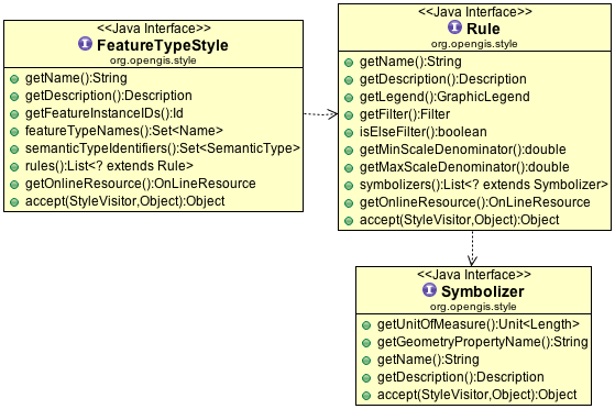
The key concepts for symbology encoding are:
FeatureTypeStyle: captures the recipe for drawing a specific kind of featureRule: used to select features for drawing, using a list of symbolizers to control the actual drawing process.Symbolizer: defining how selected features are portrayed using fill, stroke, mark and font information.
Rule
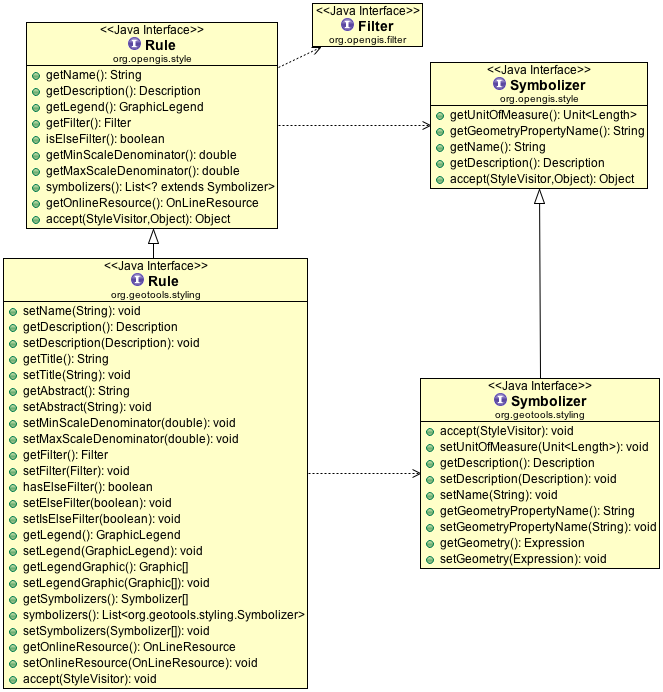
In the above example of Rule you can see that these data structures are mutable:
Rule.isElseFilter()Rule.setElseFilter()Both getters and setters are now provided.
Rule.symbolizers()provides direct access to aList<Symbolizer>You can modify the list of symbolizers directly:
rule.clear();
rule.symbolizers().add( pointSymbolizer );
Symbolizer
A Symbolizer defines how a geometry is to be rendered in terms of pixels; selecting the geometry from the feature, and drawing using the information provided here.
Note
The Symbology Encoding standard does its best to render something in all cases; thus a PointSymbolizer applied to a Polygon will draw a point in the center, more interestingly a LineSymbolizer applied to a point will draw a small line (of a fixed size) at the indicated location.
GeoTools extends the concept of Symbolizer provided by the standard allowing the geometry to be defined using a general Expression (rather than just a PropertyName references).
This facility allows a geometry to be defined using a Function expression giving users an opportunity to pre-process the geometry.
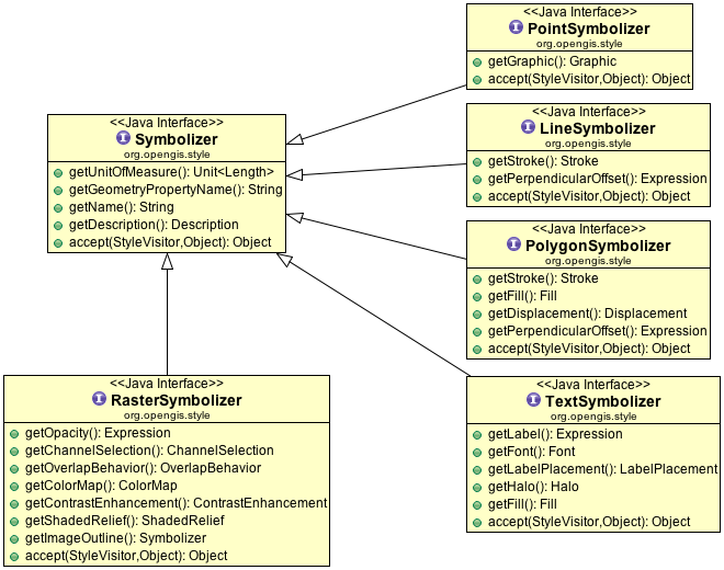
The available symbolizers are:
TextSymbolizerUsed to control the labeling system; labels are generated by
TextSymbolizersand thrown into the rendering engine which detect overlaps, sorts things out according to priorities you have defined and decides on a final label placement.LineSymbolizerUsed to control how lines (or edges) are drawn.
PolygonSymbolizerUsed to control how solid shapes are drawn.
PointSymbolizerUsed to draw a point location, the actual graphic drawn is referred to as a Mark with the option to use some well known marks (circle, square etc..) or your own external graphics such as PNG icons.
RasterSymbolizerUsed to control the rendering of raster data with full “color map” control.
Here is a quick example showing the creation of a PointSymbolizer:
        //
        org.geotools.api.style.StyleFactory sf = CommonFactoryFinder.getStyleFactory();
        FilterFactory ff = CommonFactoryFinder.getFilterFactory();

        //
        // create the graphical mark used to represent a city
        Stroke stroke = sf.stroke(ff.literal("#000000"), null, null, null, null, null, null);
        Fill fill = sf.fill(null, ff.literal(Color.BLUE), ff.literal(1.0));

        // OnLineResource implemented by gt-metadata - so no factory!
        OnLineResourceImpl svg = new OnLineResourceImpl(new URI("file:city.svg"));
        svg.freeze(); // freeze to prevent modification at runtime

        OnLineResourceImpl png = new OnLineResourceImpl(new URI("file:city.png"));
        png.freeze(); // freeze to prevent modification at runtime

        //
        // List of symbols is considered in order with the rendering engine choosing
        // the first one it can handle. Allowing for svg, png, mark order
        List<GraphicalSymbol> symbols = new ArrayList<>();
        symbols.add(sf.externalGraphic(svg, "svg", null)); // svg preferred
        symbols.add(sf.externalGraphic(png, "png", null)); // png preferred
        symbols.add(sf.mark(ff.literal("circle"), fill, stroke)); // simple circle backup plan

        Expression opacity = null; // use default
        Expression size = ff.literal(10);
        Expression rotation = null; // use default
        AnchorPoint anchor = null; // use default
        Displacement displacement = null; // use default

        // define a point symbolizer of a small circle
        Graphic circle = sf.graphic(symbols, opacity, size, rotation, anchor, displacement);
        PointSymbolizer pointSymbolizer = sf.pointSymbolizer("point", ff.property("the_geom"), null, null, circle);
TextSymbolizer
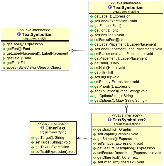
GeoTools extends the concept of a TextSymbolizer allowing:
TextSymbolizer.getPriority()Priority used to determine precedence when labels collisions occur during rendering. The label with the highest priority “wins” with the others being moved out of the way (within a tolerance) or just not displayed.
TextSymbolizer.getOption(String)Additional vendor specific options used to control the rendering process.
TextSymbolizer2.getGraphic()Graphic to display behind the text label
TextSymbolizer2.getSnippet()Used by text renderers such as KML and RSS to specify a snippet of text.
TextSymbolizer2.getFeatureDescription()Used by formats like KML or RSS to supply info on a feature.
Fill
Fill is used both to fill a polygon, and also when creating greater control over Mark appearance (where it can be used to define the interior of a Mark).

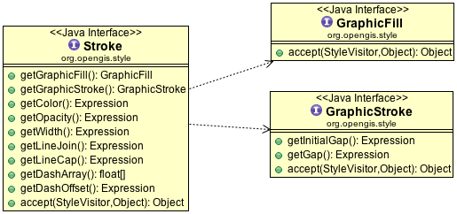
Stroke
In a similar fashion Stroke is used to render edges (either polygon edges, lines or the outside edge of a Mark).
Graphic
The idea of a Graphic is used in a number of contexts when drawing:
Graphic: As an “icon” when rendering a point locationGraphicFilter: As a pattern when filling an areaGraphicStroke: As a pattern when drawing along a lineGraphicLegend: As an entry in a legend (GeoTools does not use this one yet)
Although the symbology encoding specification defines the above distinct kinds of Graphic the GeoTools library does not distinguish between them at this time.
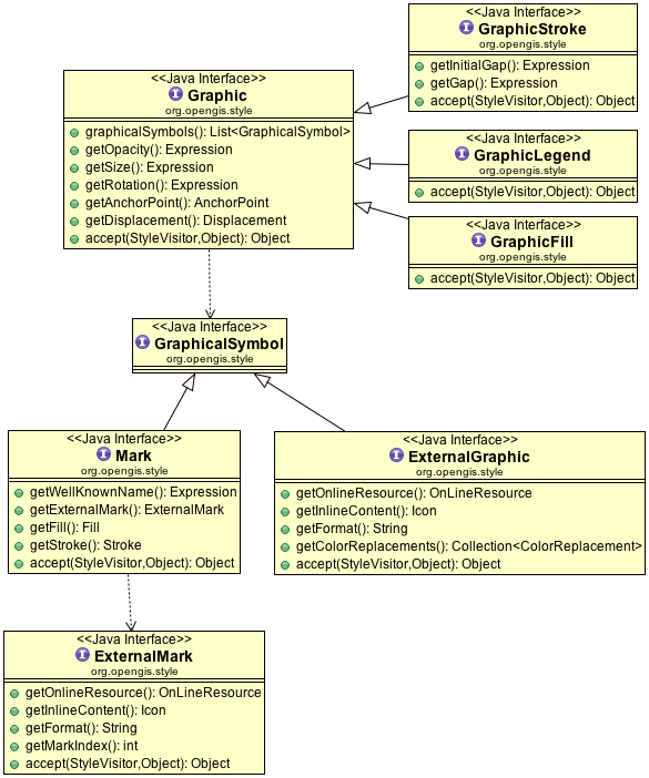
The interesting part is the list of GraphicalSymbol. This list is considered in order, with
the rendering engine selecting the first format it is able to draw allowing you to order your highest quality
ExternalGraphic formats first (such as SVG or a true type font) and moving on to lower quality choices such as PNG files and
finally ending with a fallback Mark.
ExternalGraphicIn addition to allowing you the use of SVG and image formats there is the interesting use of inline content in the form of a Java Icon allowing you greater control. You also have a chance to apply color replacements (which cab be used to render a black and white image into a set color as needed.
MarkCheck the javadocs for the list of well known names (such as “circle” or “square”). Of interest is the use of an
ExternalMarkin which the mark index can be used to refer to a specific character entry in a true type font.
StyleVisitor
A style visitor is defined allowing you to traverse the style data structure.
For general guidance on the use of a visitor please review Filter on the subject.
StyleFactory
Objects for symbology encoding are created using a StyleFactory:
org.geotools.api.style.StyleFactory sf = CommonFactoryFinder.getStyleFactory(null);
FilterFactory ff = CommonFactoryFinder.getFilterFactory(null);

Fill fill = sf.fill(null, ff.literal(Color.BLUE), ff.literal(1.0));