Feature
The Feature class is used to represents “something that can be drawn on a map”.
References:
org.geotools.api.feature (javadocs)
Feature gt-main feature code examples
Data Structure
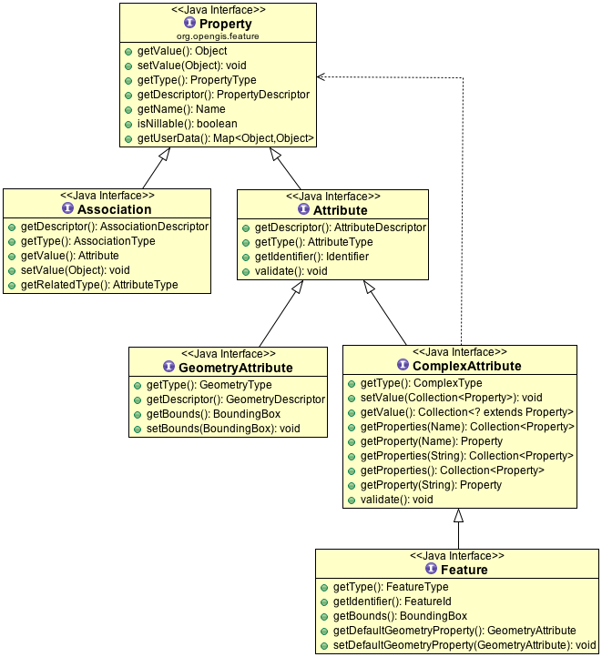
A GeoTools Feature stores your information in a data structure composed of Feature, Attributes, and Associations.
To directly create a Feature you can make use of FeatureFactory, or use a builder which makes things a little easier (as it fills in defaults):
//create the builder
SimpleFeatureBuilder builder = new SimpleFeatureBuilder(featureType);

//add the values
builder.add( "Canada" );
builder.add( 1 );
builder.add( 20.5 );
builder.add( new Point( -124, 52 ) );

//build the feature with provided ID
SimpleFeature feature = builder.buildFeature( "fid.1" );
In practice you can use a feature much like a java.util.Map to get and put values. The difference is that the “keys” are formally defined by the FeatureType (which helps us swap information between systems).
This is a little bit easier with SimpleFeature which allows direct access to attribute values:
feature.setAttribute( "turbidity", 3.7 );
Object value = feature.getAttribute( "turbidity" ); // returns double 3.7 stored above
For more information see the examples listed in gt-main Feature.
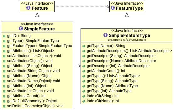
Simple Feature
Most GIS data does not need a full dynamic type system with associations, operations, multiple values. With this in mind we have a “simple” extension of Feature and FeatureType providing to represent this kind of information.
A “simple” feature is an object that can be drawn on a map (i.e. a feature) that does not contain any complicated internal structure. A SimpleFeature is “flat” recording of key value pairs. At least one of the values should be a Geometry, and the list of keys is known ahead of time.
SimpleFeature may be used when:
a feature’s properties are limited to mandatory
GeometryAttributeandAttribute(no complex attributes or multiplicity allowed).Attributes values may be null; but each attribute must be represented
order of attribute values is considered significant allowing values to be looked up by attribute name, or by the order they are listed
These restrictions match the abilities of a simple shapefile or database table
Here are the additional methods made available:
Here is an example of constructing a SimpleFeatureType:
SimpleFeatureTypeBuilder b = new SimpleFeatureTypeBuilder();

//set the name
b.setName( "Flag" );

//add some properties
b.add( "name", String.class );
b.add( "classification", Integer.class );
b.add( "height", Double.class );

//add a geometry property
b.setCRS( DefaultGeographicCRS.WSG84 );
b.add( "location", Point.class );

//build the type
SimpleFeatureType type = b.buildFeatureType();